THE LATITUDE AND LONGITUDE DATABASE
Latitude
and longitude data found on this site have been provided by contributors to the
Monroe County Historical and Genealogy website. The measurements have been made with hand-held GPS units. No
claim is made for the quality of the data.
Clearly, the precision of the data can be affected by the quality of the
instrument used to measure it, as well as reading and recording errors, and
such. The user of this data is
cautioned to recognize that such problems can occur and to allow for some
errors. Such errors not withstanding,
latitude and longitude of specific sites measured by a GPS is likely to be
infinitely more precise and useful for locating specific positions than
alternatives, such as maps and directions.
Coordinate
data will be added to the database as it becomes available. Anyone having coordinate data for specific
sites is encouraged to submit it for inclusion on this web site. For the purpose of standardization, it is
preferred that data be submitted electronically and that the format be the same
as that which has been used in the web site database. Of course, if it is not in the optimum format, send it anyway --
we will be glad to receive whatever you have.
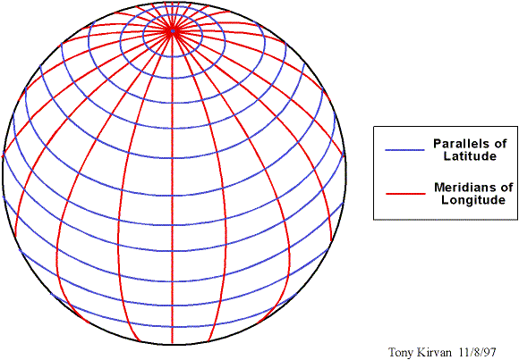
Latitude
and Longitude (a refresher) Do you remember looking at a globe of the earth and
seeing the lines that run from the north pole to the south pole. Those are lines or meridians of
longitude. They are red in the sketch
below. Then, recall the equator that
runs around the earth dividing the northern hemisphere from the southern
hemisphere. Also, recall the circles
going around the earth as you go from the equator to the north or south
pole. These are parallels or lines of
latitude. They are blue in the picture
below.
These
lines are not actually on earth, of course, just on our globe. But, if they were painted on earth we would
see and cross over red lines of longitude as we walked in an east-to-west or
west-to-east direction. If we walked in
a north-to-south or south-to-north direction we would see and cross over blue
lines of latitude.
Imagine
for a moment that the earth is painted with lines of latitude and longitude and
that each line is given a number. Since
we are working with circles (the globe) the numbers would be in degrees. Don t panic, we will not have to do any
calculations with the degrees they are just used as the names or numbers of
the lines of latitude and longitude.
Now
since there are 360 degrees in a circle, if we painted lines of latitude or
longitude at every single degree, there would be 360 lines of longitude painted
on the earth with each of them starting at the north pole and running to the
south pole (and vice versa). They would
be the red lines in the sketch above.
All 360 of these red lines of longitude would converge at both
poles. At the equator, these lines of
longitude would have their maximum separation from each other. In fact, at the equator, which is about
24,000 miles measured around the earth, the distance between each of the
one-degree line of longitude and its neighbor would be about 66 English miles
(meaning, a 5,280 foot mile like we use in England and America for measuring a
mile). If we use nautical miles that
equal 1.1 English miles, then the distance between one degree of longitude at
the equator is exactly 60 nautical miles.
When
the navigators and astronomers figure all this out a few hundred years ago,
they decided that since the earth rotated 60 miles in each degree of rotation,
they would subdivide each degree into 60 parts and call them minutes like the
60 minutes that we use to subdivide an hour of time. So in addition to having the earth divided into 360 degrees, each
degree is further subdivided into 60 minutes.
We can now paint (say, pink) lines of longitude between each neighboring
red line of longitude. Now, as we walk
from east-to-west (or vice versa) we will see 60 pink lines between each pair
of red lines of longitude. At the
equator, each pair of neighboring pink lines (that is, each minute of
longitude) will be about 1.1 English miles or 1.0 nautical mile.
Let s
stop there with our subdividing because for our purposes, degrees and minutes
are all that is necessary.
You
can paint the earth with blue lines of latitude in the same way that we did
longitude. So, as you walk north and
south (or vice versa) you come across (dark) blue lines of degrees of latitude
and (light) blue lines of minutes of latitude.
You
can now see that we have divided the earth into tiny blocks with our red, pink
and blue lines of longitude and latitude.
And, since each line has its own distinctive number, we can locate
almost anything on earth by giving the number of the nearest lines.
This
is a great system for locating things on earth and since these lines of
latitude and longitude never changes, it provides a way of locating and
communicating the location of whatever we like to other people including others
who may be born, say, hundreds of years in the future.
Great,
you say, but just how do we measure these latitudes and longitudes? The answer is, With a Global Positioning
System (GPS).
What
is a Global Positioning System (GPS) As some of us may remember and others may have
studied in history, following WW II, there developed a major Cold War between
the United States and Russia. The
tension of that conflict became so serious that it appeared that a Hot War
might develop. One of the weapons of
choice for both sides in the conflict was the Intercontinental Ballistic
Missile (ICBM). But to be able to use
an ICBM effectively, a system was needed that could measure latitudes and
longitudes with great precision. The
answer to that requirement was the Global Positioning System (GPS).
The
GPS that was developed consists of a large number of satellites that orbits the
earth. These satellites are in what is
called Polar Orbits meaning that their orbits take them over the north and
south poles. The exact location of each
satellite is precisely known at all times.
Each satellite continuously transmits a radio signal back to earth. There are enough of these satellites in
orbit that every spot on earth has at least 3 or more satellites overhead at
all times. Because their orbits are so
high, each satellite can see a large sector of the earth so the number of
satellites can be kept to a reasonably small number.
By
receiving signals from several (usually 3 to 5) satellites, it is possible to
determine your position on earth with great accuracy (usually, within about 10
to 30 feet). This is done using a GPS
unit. A GPS unit is about the size of a
cell phone. It is similar to a radio
direction finder in that it receives the transmissions from satellites overhead
and through a process called triangulation calculates the precise location of
the GPS unit. The results of this
calculation are given directly in degrees and minutes (and decimals of minutes
to the nearest one-thousandth of a minute).
Although
the Cold War is over and the need for ICBMs has diminished, the GPS continues
to provide a valuable service. It is used
by navigators aboard ships, airplanes, and automobiles. It is also used by hikers and
sportsmen. It continues to be used for
military purposes such as precision targeting of missiles and smart
bombs. And, it is also used by
historians and genealogists for locating sites of villages, towns, buildings,
cemeteries and graves that will ultimately vanish.
What
is a Latitude and Longitude Database (L/L Database)? The Latitude
and Longitude Database as used on this site is a collection of precise
locations of possible future importance.
An example is the measurement of the precise locations of cemeteries and
grave sites that are at risk of being lost over the next few years or decades. The combination of efforts to inventory
graves within each cemetery and the L/L Database will preserve the location of
graves even if the visible cemetery markers are lost or removed.
For
guidance on how you can use L/L data found on this site to locate specific
places, click here.
Use the Back-arrow at the top of this web-page to return to the Previous Page.